![](/images/other/stat-length.png)
![Randonnée Marche La Caunette - 34 - LA CAUNETTE - 13.8 Km - 04h00 - D 350 m - Photo](https://media.geolcdn.com/t/1900/400/ext.pjpeg?maxdim=2&url=https%3A%2F%2Fstatic1.geolcdn.com%2Fsiteimages%2Fupload%2Ffiles%2F1553511878bg_sport_marche.png)
34 - LA CAUNETTE - 13.8 Km - 04h00 - D 350 m
dansmabulle
Utilisateur
![Longueur](/images/other/stat-length.png)
![Altitude max](https://static1.geolcdn.com/siteimages/upload/files/1508320355ic_sort_altitude_max_24dp.png)
![Dénivelé positif](https://static1.geolcdn.com/siteimages/upload/files/1508320355ic_sort_den_pos_24dp.png)
![Km-Effort](/images/other/stat-length.png)
![Altitude min](https://static1.geolcdn.com/siteimages/upload/files/1508320355ic_sort_altitude_min_24dp.png)
![Dénivelé négatif](https://static1.geolcdn.com/siteimages/upload/files/1508320355ic_sort_den_neg_24dp.png)
![Boucle](https://static1.geolcdn.com/siteimages/upload/files/16400158638029165_repeat_loop_refresh_sync_direction_icon.png)
![Marche](https://static1.geolcdn.com/sitytour/trail-icons/101.png)
4h06
Difficulté : Difficile
![Scannez ce code QR pour ouvrir la randonnée dans l'application SityTrail](https://capi.geolives.com/qq0zvz2zws4bq2lad0pu/sitytour/trails/249031/qr.png?size=200)
Application GPS de randonnée GRATUITE
À propos
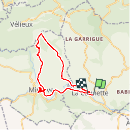
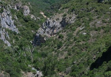
Randonnée Marche de 13,8 km à découvrir à Occitanie, Hérault, La Caunette. Cette randonnée est proposée par dansmabulle.
Description
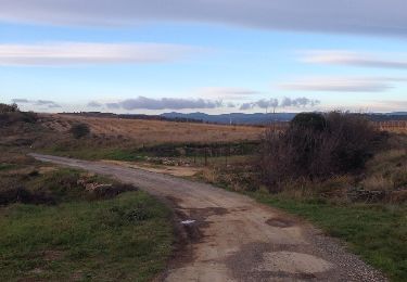
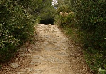
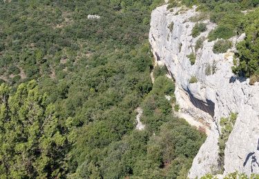
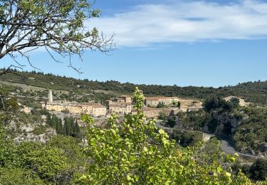
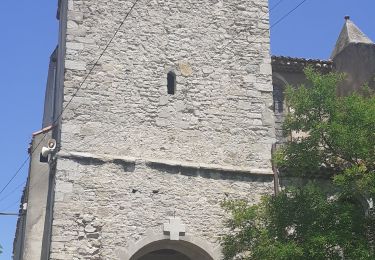
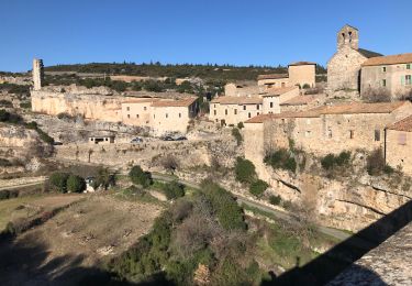
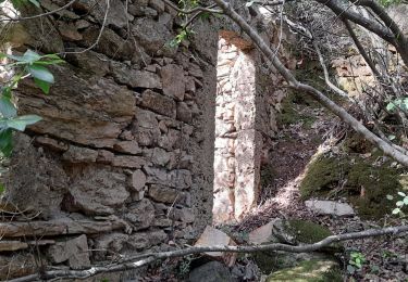
Départ randonnée : La Caunette, à coté de Notre Dame de la Cesse (hérault) Nous traverserons la Cesse et nous nous dirigerons vers Mayranne en traversant la gorge sur une petite passerelle. Nous poursuivrons ensuite vers le nord par le causse de oupiat et de Mayranne jusqu'au Méjanels.Nous emprunterons ensuite une allée forestière plein sud en faisant quelques escapades pour admirer les gorges du Briant.Après la Courounelle, nous continuerons sur le causse jusqu'à la catapulte avec de très belles vues sur Minerve haut fief de la résistance Cathare.Après la visite de la ville nous reprendrons un chemin plein est pour rejoindre la voiture.Bonne randonnée.
Localisation
Commentaires
Randonnées à proximité
![Randonnée Marche Aigne - Aigne - Saume Longue - Photo](https://media.geolcdn.com/t/375/260/ext.jpg?maxdim=2&url=https%3A%2F%2Fservices.sitytrail.com%2FGeolivesWS%2FDownloadMedia.ashx%3FTrailID%3D373254%26Media%3D20141229163850.jpg)
![Marche Marche](https://static1.geolcdn.com/sitytour/trail-icons/101.png)
Marche
![](/images/other/stat-length.png)
![](https://static1.geolcdn.com/siteimages/upload/files/16400158638029165_repeat_loop_refresh_sync_direction_icon.png)
![Randonnée Marche Aigues-Vives - croix de St Félix boucle pech de agel - Photo](https://media.geolcdn.com/t/375/260/ext.jpg?maxdim=2&url=https%3A%2F%2Fservices.sitytrail.com%2FGeolivesWS%2FDownloadMedia.ashx%3FTrailID%3D550688%26Media%3Dfix__20160408124301.jpg)
![Marche Marche](https://static1.geolcdn.com/sitytour/trail-icons/101.png)
Marche
![](/images/other/stat-length.png)
![](https://static1.geolcdn.com/siteimages/upload/files/16400158638029165_repeat_loop_refresh_sync_direction_icon.png)
![Randonnée Marche La Caunette - La Caunette - Photo](https://media.geolcdn.com/t/375/260/18583847-6773-463a-b6f4-5c9be80f48ff.jpg&format=jpg&maxdim=2)
![Marche Marche](https://static1.geolcdn.com/sitytour/trail-icons/101.png)
Marche
![](/images/other/stat-length.png)
![](https://static1.geolcdn.com/siteimages/upload/files/16400158638029165_repeat_loop_refresh_sync_direction_icon.png)
![Randonnée sport Minerve - Minerve bouclé Hérault - Photo](https://media.geolcdn.com/t/375/260/d578c921-3c99-4e11-b589-7310c0cb7ada.jpg&format=jpg&maxdim=2)
sport
![](/images/other/stat-length.png)
![](https://static1.geolcdn.com/siteimages/upload/files/16400158638029165_repeat_loop_refresh_sync_direction_icon.png)
![Randonnée Marche Azillanet - Azillanet Minerve - Photo](https://media.geolcdn.com/t/375/260/17a8c3f2-392a-4950-a09a-5c0f5e3f5c78.jpg&format=jpg&maxdim=2)
![Marche Marche](https://static1.geolcdn.com/sitytour/trail-icons/101.png)
Marche
![](/images/other/stat-length.png)
![](https://static1.geolcdn.com/siteimages/upload/files/16400158638029165_repeat_loop_refresh_sync_direction_icon.png)
![Randonnée Marche La Caunette - La Caunette - Photo](https://media.geolcdn.com/t/375/260/023ef97f-7396-4efd-82f5-9f38cf32c62c.jpg&format=jpg&maxdim=2)
![Marche Marche](https://static1.geolcdn.com/sitytour/trail-icons/101.png)
Marche
![](/images/other/stat-length.png)
![](https://static1.geolcdn.com/siteimages/upload/files/16400158638029165_repeat_loop_refresh_sync_direction_icon.png)
![Randonnée V.T.T. Minerve - minerve - Photo](https://media.geolcdn.com/t/375/260/99c6c1a4-f768-4c35-9e57-edeb97d705f4.jpg&format=jpg&maxdim=2)
![V.T.T. V.T.T.](https://static1.geolcdn.com/sitytour/trail-icons/202.png)
![Randonnée A pied Minerve - Les Mégalithes de Minerve - Photo](https://media.geolcdn.com/t/375/260/09b6594c-9884-4989-80d8-c89c14cd8660.jpeg&format=jpg&maxdim=2)
![A pied A pied](https://static1.geolcdn.com/sitytour/trail-icons/100.png)
A pied
![](/images/other/stat-length.png)
![](https://static1.geolcdn.com/siteimages/upload/files/16400158638029165_repeat_loop_refresh_sync_direction_icon.png)
![Marche Marche](https://static1.geolcdn.com/sitytour/trail-icons/101.png)
Marche
![](/images/other/stat-length.png)
![](https://static1.geolcdn.com/siteimages/upload/files/16400158638029165_repeat_loop_refresh_sync_direction_icon.png)
Rando tranquille mais superbe, à faire.